Participatory Mapping
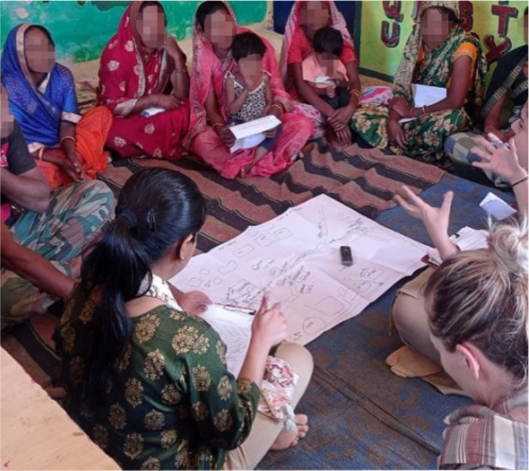 Overview of Participatory Mapping of Food Environment. The Participatory Mapping tool is designed to be conducted prior to the other food environment assessments included in the Food Environment Toolbox to help inform which tools to use as well as the sampling approach for a given study. As part of a focus group discussion conducted with community members who are familiar with the different food access points within the community, the Participatory Mapping tool guides participants to draw a map of the different wild, cultivated, built, kin and community, and supplemental food assistance spaces they access food from in the community. The tool guides participants to describe which foods they access from those spaces and why. The focus group guide has been informed by the participatory mapping literature (Cochrane & Corbett, 2020; Corbett, 2009), previous studies conducted by our team using this method (Downs et al., 2019; 2022; 2024), and the USAID Advancing Nutrition Guidelines for Market-Based Food Environment Assessments (2023). This tool provides insight into the different types of food environments that communities access, where and how they acquire different types of foods, and how these change across seasons and time.
Participatory Mapping Cover Page
Participatory Mapping Instructions

-
To identify the types of food environments that are accessed by the community and to inform the sampling of other tools included in the Toolbox.
-
You should use this tool if you are unsure of how community members interact with their food environments and want to inform which food environment domains, dimensions, and tools you should target in your data collection.
-
One focus group discussion with approximately 6-8 participants should be conducted per study community. Purposive sampling can be used to identify participants in the community that are primary shoppers for the household as well as those with knowledge about the wild and cultivated environments accessed within the community.
-
Participatory Mapping captures aspects of the perceived food environment as well as information about different food environment types.
-
Participatory Mapping assesses aspects of the dimensions of food availability, affordability, convenience, and sustainability.
-
A focus group facilitator will moderate the discussion using the focus group guide. Focus group participants will draw a map of their community food environment.
-
- Focus group discussion with members of community
- Drawing map of community food environment
-
We provide tables that can be completed during, or directly after, the focus group discussion that summarize the key findings from the discussions. These data can be used to describe the different food access points in the community, which foods are obtained from each of the access points, and how people get there and how long it generally takes them to get there. For more in-depth analyses of the focus group discussions, you can transcribe discussions and analyze the transcripts qualitatively based on standard approaches to qualitative data analysis.
-
The strengths of this tool include its ease of administration, participatory engagement with participants, its ability to inform data collection approaches, and the limited resources needed to implement it.
-
The quality of the data will depend on the knowledge of the participants included in the focus group and may not represent the experience of all community members. The tool takes a significant amount of participant time (~90 minutes), and the data obtained will be qualitative and will require resources for analysis if thematic analysis is desired. However, we provide a template for quick analyses to inform subsequent data collection approaches.
-
Cochrane L, Corbett J. Participatory mapping. In: J Servaes editor. Handbook of communication for development and social change. Singapore: Springer Singapore (2020). p. 705–13
Corbett J. Good practices in participatory mapping: A review prepared for the International Fund for Agricultural Development (IFAD). Rome: International Fund for Agricultural Development (IFAD) (2009).
Downs, S.M., Glass, S., Linn, K.K. and Fanzo, J., 2019. The interface between consumers and their food environment in Myanmar: an exploratory mixed-methods study. Public health nutrition, 22(6), pp.1075-1088.
Downs, S.M., Fox, E.L., Mutuku, V., Muindi, Z., Fatima, T., Pavlovic, I., Husain, S., Sabbahi, M., Kimenju, S. and Ahmed, S., 2022. Food Environments and Their Influence on Food Choices: A Case Study in Informal Settlements in Nairobi, Kenya. Nutrients, 14(13), p.2571.
Downs, S., Manohar, S., Staromiejska, W., Keo, C., Say, S., Chhinh, N., Fanzo, J. and Sok, S., 2024. Centering context when characterizing food environments: the potential of participatory mapping to inform food environment research. Frontiers in Nutrition, 11, p.1324102.
USAID Advancing Nutrition. 2023. Guidelines for Market-Based Food Environment Assessments. Instruction Manual. Arlington, VA: USAID Advancing Nutrition.