Regional Stormwater Management Planning for the Highlands Portion of Watershed Management Area 8 – North and South Branch Raritan
- Background
- Project Location
- Project Description
- Resources
- Project Deliverables
- Project Funding Source
Background:
The New Jersey Highlands Region covers less than 15% of the state but provides drinking water for 70% of its residents. New Jersey recognized the significane of this region and passed the Highlands Act in 2004 to protect the valuable resources in this region. The Highlands Act advocated for a regional planning approach to protect and restore the waterways of the New Jersey Highlands. This project seeks to embrace the regional planning concept and focus on identifying opportunities in the watersheds of the Highlands for green infrastructure to manage uncontrolled sources of stormwater runoff.
Focusing on the Highlands portion of Watershed Management Area 8 – North and South Branch Raritan, the RCE Water Resources Program will complete green infrastructure plans on a municipal basis and provide summaries of proposed green infrastructure projects by subwatershed to help prioritize project implementation. Since the information in each of these municipal green infrastructure plans is prepared on a subwatershed basis, information for subwatersheds will be combined from the municipal plans to summarize recommendations on a HUC 14 basis.
Project Location:
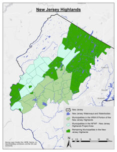
Project Description:
Task 1 – Prepare impervious cover assessments (ICAs)
The RCE Water Resources Program will prepare an impervious cover assessment for each of the 24 municipalities in the Highlands portion of WMA 8 – North and South Branch Raritan River Watershed.
Task 2 – Prepare impervious cover reduction action plans (RAPs)
Using the data gained from the ICA, the RCE Water Resources Program will develop a RAP for each of the 24 municipalities in the watershed. The sites from the RAP will be incorporated into a web-based interface (i.e., RAP web map) so the general public can easily access the recommendations.
Task 3 – Create green infrastructure feasibility studies
The RCE Water Resources Program will prepare a green infrastructure feasibility study for each of the 24 municipalities in the watershed.
Task 4 – Summarizing findings and recommendations on a HUC 14 watershed basis
Since each plan provides analyses on a subwatershed basis, results and recommendations from several adjacent municipalities can be used to summarize information on a HUC 14 watershed basis. This will allow for a regional approach to prioritize projects and better understand the effects projects in one municipality may have on another municipality.
Resources:
Highlands Region Map and Quick Facts (11×17 pdf; New Jersey Highlands Council)
Access the Green Infrastructure Guidance Manual for New Jersey.
Project Deliverables:
- Final Report – Regional Stormwater Management Planning for the Highlands Portion of Watershed Management Area 8 – North and South Branch Raritan, July 23, 2021 (pdf, 37 pp.)
- Regional Stormwater Management Planning for the Highlands Portion of North and South Branch Raritan River, April 15, 2021 (pdf of PowerPoint presentation, 31 pp.)
- Links are provided to the impervious cover assessments (ICA), impervious cover reduction action plans (RAP), and feasibility studies completed for each of the municipalities in the Highlands portion of WMA8 – North and South Branch Raritan.
Hunterdon County
Alexandria Township
Bethlehem Township
Califon Borough
Town of Clinton
Clinton Township
Glen Gardner Borough
Hampton Borough*
-
-
- ICA
- RAP
- Feasibility Study
-
*Previously completed with funding from the William Penn Foundation.
High Bridge Borough
Lebanon Borough
Lebanon Township
Tewksbury Township
Union Township
Morris County
Chester Borough
Chester Township
Mendham Borough
Mendham Township
Mine Hill Township
Mount Arlington Borough*
-
-
- ICA
- RAP
- Feasibility Study
-
*Previously completed with funding from the William Penn Foundation.
Mount Olive Township*
-
-
- ICA
- RAP
- Feasibility Study
-
*Previously completed with funding from the William Penn Foundation.
Randolph Township
Roxbury Township
Washington Township
Somerset County
Bedminster Township
Bernards Township
Bernardsville Borough
Far Hills Borough
Peapack-Gladstone Borough
Project Funding Source:
