Kawalec, Jason: Exploration of Structure from Motion Programs and their Application to Improving Student Learning in Geoscience Classrooms
Title: Exploration of Structure from Motion Programs and their Application to Improving Student Learning in Geoscience Classrooms
Name: Jason Kawalec
Major: Geological Sciences: Planetary Science
School affiliation: School of Arts and Sciences
Programs: Aresty Summer Science Program
Other contributors: Lauren N. Adamo
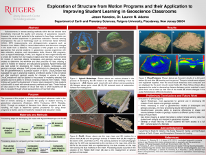
Abstract: Advancements in remote sensing methods within the last decade have dramatically improved the quality and accuracy of geoscience research. However, there is much potential to be explored in how these methods can improve the student experience in geoscience education. Remote sensing encompasses the use of technology such as Unmanned Aerial Vehicles (UAVs), GPS measurements, and photogrammetry programs such as Structure from Motion (SfM) to record observations and document changes in the Earth from a distance. The purpose of this project is to develop approaches that provide students in geoscience courses experience with data collection, analysis, and interpretation skills. Several SfM programs, such as Agisoft Metashape, Pix4D, and Regard 3D were experimented with to create 3D models from 2D images of objects and field sites. Fully rendered 3D models of inanimate objects, landscapes, and geologic outcrops were created to determine the workflow and best practices for later creating a cache of models for research and educational purposes. Agisoft Metashape was best suited for developing 3D models of objects, landscapes, and geologic outcrops, whereas Pix4D proved satisfactory for developing models that are georeferenced to a precise location on Earth. CloudCompare was evaluated for use in analyzing locations at different points in time or before and after significant geologic events for changes in volume or shape. CloudCompare will also be applied to the process of modeling selected rock samples due to its ability to remove extraneous features from models. These findings will guide the development of lesson plans designed to help students cultivate skills to work with remote sensing methods and data. These findings will also assist in the creation of virtual field trips in which students will be able to navigate through virtual representations of real field sites.