Capstone
The Senior Design Capstone Project is a collaborative program where engineering students gain hands-on design experience by developing innovative product prototypes. This project allows students to apply their theoretical knowledge to real-world engineering challenges, including sustainability and health and safety considerations.
If you’re interested in working with me, send me an email to discuss potential project topics.
Past projects
Spring 2026
Modular Agricultural Drone System (MADS)
Abstract: Agricultural fertilization remains highly inefficient, with crops absorbing only a limited fraction of applied nutrients, approximately 48% for nitrogen and just 12.6% for phosphorus on a global scale. The excess can contaminate groundwater, increase greenhouse-gas emissions, and impose major economic costs; the EPA estimated nitrogen and phosphorus pollution at $2.4 billion in 2015. An important cause is the widespread use of uniform fertilizer application methods, which ignore spatial variation in plant nutrient demand within a field. As a result, conventional spraying can overfertilize some areas and underfertilize others, reducing efficiency and increasing environmental losses. To address this challenge, we developed a drone-based precision fertilization system that combines aerial sensing, deep-learning-based plant analysis, and targeted spraying. The system first performs a top-level scan of the field to collect image data, which is then processed on a ground station to identify regions and plants that require additional fertilizer. The proposed framework enables localized, perception-guided fertilizer application, offering a path to higher nutrient-use efficiency and lower environmental losses than conventional field-wide methods.
Team members: Neel Shah, Daniel Rydzewski, Devin Weng, Edward Kramer, Vachan Gajjar
Poster: MADS_Poster

High-Resolution Urban Fire-Risk Mapping Using Low Altitude Drone
Abstract: Wildfires are an escalating threat in the United States, posing increasing risks to lives, property, ecosystems, and critical infrastructure. One important challenge in wildfire science is estimating fuel mass, as the quantity and spatial distribution of available fuel play a fundamental role in fire spread and in the generation of fire-risk maps. Existing solutions commonly rely on satellite-derived vegetation solutions and standard fuel datasets such as LANDFIRE. Although these tools are useful for regional and landscape-scale analysis, their spatial resolution is often too coarse to resolve the fine-scale heterogeneity that determines local risk, particularly in Wildland–Urban Interface areas where vegetation, terrain, and structures interact in complex ways. Here, we present a drone-based machine learning framework for fuel-mass estimation and mapping. Our goal is to enable more precise and geospatially consistent characterization of wildfire hazards, with the long-term aim of improving prevention, preparedness, and risk-informed decision-making in vulnerable communities.
Team members: Samanthia Welsh, Sam Schaeffer, Isabella Valadez, Christian Pervolarakis
Poster: Urban Fire-Risk Mapping_poster

Spring 2025
Photo Album: link
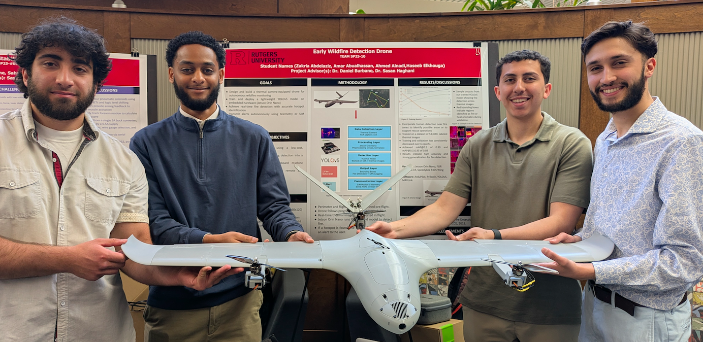
Early Wildfire Detection Drone (8th Place out of 53 teams)
Abstract: Wildfires pose escalating threats to human life, ecosystems, and infrastructure. This project presents a low-cost, autonomous drone system for early wildfire detection and rapid response. In contrast to conventional two-drone strategies, where one drone performs high-altitude surveillance and another conducts a low-altitude inspection, our solution combines both functions into a single platform. Equipped with a thermal camera and powered by onboard processing via the Jetson Orin Nano, the drone uses a YOLOv5-based machine-learning model trained specifically on low-resolution thermal imagery to detect fire hotspots in real-time. The proposed approach seeks to minimize response time, reduce system complexity, and support scalable wildfire monitoring in remote or resource-limited regions.
Team members: Zakria Abdelaziz, Amar Abualhassan, Ahmed Alnadi, Haseeb Elkhouga
Poster: SP25-10 Expo Poster_2025
Spring 2024
Photo Album: link
RailVision: Overgrowth Detection Drone (3rd Place out of 52 teams)
Abstract: Every year, billions of dollars are spent towards railroad maintenance, with vegetation overgrowth maintenance being a prominent issue. Vegetation overgrowth creates fire hazards, infrastructure damage, and lead to many negative economic and environmental impacts. To address this problem, we built an autonomous VTOL drone using an energy efficient 4+1 quadplane configuration. Utilizing our image classifying CNN (RailNet), our quadplane autonomously flies alongside rail lines, detecting vegetation overgrowth in real time. Through RailVision, we aim to contribute to the safety of maintenance workers, address the inefficiencies of current overgrowth inspections, increase the lifespan of railroad infrastructure, and make leaps toward preventing wildfires to better conserve our environment.
Team members: Osmin Nolasco, James Sullivan, Steeve Cantave, Dhruv Patel
Poster: RailVisionPoster

Human Motion Estimation for Interactive Rehabilitation (8th Place out of 52 teams)
Abstract: Sarcopenia is a musculoskeletal condition characterized by a loss of muscle and strength that affects a large portion of the elderly population globally. The condition can only be treated with physical therapy. However, not everyone who could benefit from PT is able to use it, either due to cost or location. The goal of our project is to provide a low-cost, at-home alternative to PT, using small integrated internal measurement units (IMUs) to track limb movements using inverse kinematics. This is paired with our software, which guides the user through different therapeutic exercises based on their goal, and gives them feedback on their performance. The results, although preliminary, indicate that this method can help patients reduce the effects of sarcopenia, and provide a way for progress to be tracked over time.
Team members:Ronan John, Daniel Gameiro, Marco Garcia-Palma
Poster: HumanMotionEstimationPoster
Spring 2023
The LanternPredator (6th Place out of 71 teams)
Abstract: Lanternflies are an invasive pest species that can cause significant economic damage to agriculture by affecting plants and crops and disrupting the balance of natural ecosystems. These insects have a fast reproduction cycle, can withstand high-temperature variations, and have no natural predators in the US, making it very difficult to control their spread. Motivated by this environmental issue, we designed the LanternPredator, an autonomous pest control robot to help control the population growth of lanternflies. The proposed solution integrates machine learning algorithms for detecting the right insect species, an acoustic stimulus to attract the insects to a zap trap, and sonar for autonomous navigation.
Team members: David Banyamin, Wei Gou, Mark Rezk, Wictor Fedorowiat
Poster: LanternPredator
Pics: Photo Gallery
Fall 2022
Navigation Implementation of Industrial Vehicles
Abstract: Smart warehousing is the process of automating all the activities performed in a regular warehouse where raw materials and manufactured goods are stored. Smart warehousing has several advantages, from reducing operating costs and processing time to reducing human safety risks and optimizing physical storage space. The primary goal of our project is to develop an autonomous vehicle capable of navigating in a warehouse environment following a specific path. This research seeks to boost productivity in industrial settings by minimizing the wasteful movement of robotic vehicles, resulting in less time lost. This can open the door to a more general setting where a swarm of cooperative robots can fully automate the warehouse.