Costa Rica is a beautiful country built amid volcanoes, rainforests, rivers, and cloud forests. Every corner of this country looks like a scene right out of a movie. During our visit, one of the most frequently heard phrases was “pura vida” which translates to “pure life”. Considering that Costa Rica’s slogan promotes clean living and it’s built around so many viable sources of renewable energy, it’s no surprise that 99.78% of the energy supplied to Costa Rica comes from renewable sources. Volcanoes are a great source of renewable energy, supplying 15% of renewable energy, with the rest being from hydroelectric sources.
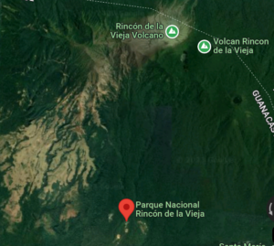
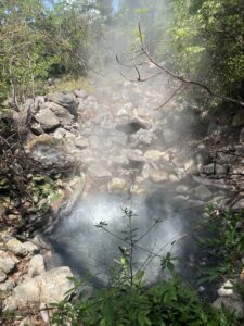
Geothermal energy is robust and reliable in the Cañas Dulces caldera in the northwest of Costa Rica. The Borinquen geothermal system located in this ideal location harnesses geothermal energy from the Rincon de la Vieja volcano (Figure 1). We were able to visit Rincon de la Vieja National Park and experience the magnitude of geothermal energy for ourselves. The volcanic area is filled with fumaroles, mud pots, bubbling hot pools, and hot springs (figure 2).
Geothermal explorations by Costa Rican Electricity Institute (ICE) show potential for this location to be an ideal site for developing geothermal reservoirs. Cañas Dulces caldera has abundant thermal anomalies, specifically in the Borinquen and Las Pailas regions. This volcano has the potential to generate up to 140 megawatts of energy. For reference, 100 megawatts of energy can power more than 16,400 homes in the United States!! Due to the area within the national park being protected, there hadn’t been any developments to harness that energy until 2001. However, in 2013 a geothermal field started being constructed in Las Pailas, and plans for a second one are currently underway. The power plant in Las Pailas is a 35MWe plant which would be accompanied by a 55MWe plant. Together they will be able to power 14,760 homes. Several geological, geophysical, and geochemical studies have been conducted on the hydrothermal system in the Borinquen region to understand the best ways to harness energy. These studies access the mineral composition, reactions between rocks and hydrothermal fluids, electric and magnetic fields, and composition and heat signatures of the hydrothermal parts. Green energy can be accessed at this location by drilling closer to the source of hydrothermal energy. It’s essential that ICE has all the necessary information before proceeding with drilling as it’s an expensive endeavor costing 2.5 to 4 million US dollars for a 2000m well. Factors that would make a site unsuitable include poor access, irregular topography, a water network with deep channels, and the importance of tourism in the Rincon de la Vieja national park we visited. Tourism is an important consideration because it’s a big source of revenue for Costa Rica, and nobody wants to see or hear a large, loud, ugly powerplant in the midst of the beautiful sights offered by the Rincon de la Vieja National Park.
One proposal for developing the Borinquen zone is by using directional drilling, which allows several wells to be drilled from one drilling site. To explain in simple terms, it’s like using a bent straw with holes in a shallow bowl so that you can suck up more liquid. Using one such bent straw can allow you to get more liquid than five regular straws hitting the bottom of the bowl. Directional drilling also allows for such benefits. You can use one drilling pad to access many wells. As a result of directional drilling the need for land and resources is also reduced. This will result in lower costs and environmental impact as well. Considering the insane price of up to 4 million dollars for drilling a well, lowered prices are necessary. This method can be implemented using drilling rigs used by ICE. The existing geothermal field in Las Pailas gives us an estimate of the area needed to construct the drilling pads, which is estimated to be around 25600m^2, or a little less than five football fields.
Another challenge is that the project is located in an area with steep and irregular slopes. There’s a limited amount of flat space that’s the size of five football fields for drilling pads. An ideal location will be low cost, sitting on a low gradient slope, with minimized chance of landslides. To make sure we minimize the environmental impact of the drilling, the sediments from drills shouldn’t contaminate any water sources such as rivers or streams. Drilling sites also need to be placed away from tourist centers and related infrastructure. As a result, drilling sites needs to be chosen with a buffer of 100m from water sources and 400m from tourist areas for sound pollution. Since there’s an existing geothermal plant in the area, any new drilling site should be around 200m from the existing location. All these factors combined with the geophysical, geochemical, and geothermal factors like enthalpy, resistivity, thermal gradient, and tectonic structures make finding a suitable location to drill to be challenging. At the end of the day, pura vida can mean anything from green energy, noise-free national parks, and a clean environment.
References
COSTA RICA. (2014). Caribbean Update, 30(8), 5-8. Retrieved from https://login.proxy.libraries.rutgers.edu/login?qurl=https%3A%2F%2Fwww.proquest.com%2Ftrade-journals%2Fcosta-rica%2Fdocview%2F1556007727%2Fse-2%3Faccountid%3D13626
Molina, F., & Marti, J. (2016). The Borinquen geothermal system (Canas Dulces Caldera, Costa Rica). Geothermics, 64, 410–425. https://doi.org/10.1016/j.geothermics.2016.07.001
Molina, F., & Martí, J. (2018). Proposal for an initial development strategy for the Borinquen geothermal zone (Cañas Dulces, Costa Rica). Renewable Energy, 118, 409–424. https://doi.org/10.1016/j.renene.2017.11.034