What data does the Research Vessel Atlantis collect while at sea?
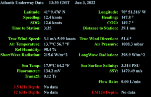
While teams like our PUFINS crew rent out the ship for research at sea, Woods Holes Oceanographic Institute with the R/V Atlantis are constantly collecting their own data for scientific research. Atlantis is equipped with Meteorological sensors (MET sensors) that are used to measure climate and weather. The sensors recording MET data on the R/V Atlantis include: Air Temperature, Barometer (atmospheric pressure), Humidity, Wind, Shortwave Radiation (solar strength), and Longwave Radiation (solar reflection).
Much of the data collected is plotted by computer software and available for viewing by all on the ship. The image below is an example of the data available on R/V Atlantis, through the ship’s intranet while onboard.
In addition to meteorological data the R/V Atlantis is collecting sea conditions. If you are wondering what sea conditions are, don’t worry I wasn’t sure either. Sea conditions are recorded by three systems 1 for data collection that is high tech., the Kongsberg Seapath system, and the confirmation system of fixed precision mounted antenna, and a third system is used by the bridge. Data is being collected for the yaw, heave, sway and surge.
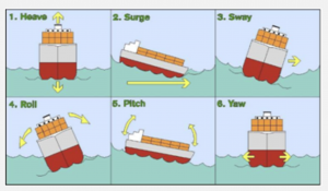
I had never put names to these conditions, but I have definitely felt these sea conditions before. Not very scientific, but if the boat’s rocking then you are experiencing more significant heave, surge, sway, roll, pitch, and/or yaw. See the photo below for what they are in relation to a ship.
Finally, while at sea the Atlantis collects data on the oceans, salinity, temperature, and fluorometer. The sensors found in the lower bow of the ship draw water in, record, and then put the water back into the ocean. While temperature in Celsius doesn’t need much explaining, salinity and fluorometry may not be terms you use often. The ocean’s salinity is the amount of salts present. The fluorometer measures a specific point and time for the amount of photosynthesis taking place by underwater photosynthetic organisms.
Most of the data above is displayed on screens in the science labs so we always know where we are and what the sea conditions are.